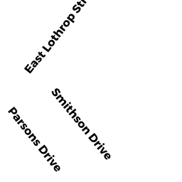
14 SMITHSON DR
Owner Information
RHOADES MARY
14 SMITHSON DR
BEVERLY, MA 01915


Property Details
14 SMITHSON DR is classified as a Single Family Residential (Cape).
The primary structure on this property was built in 1948. There are 1,296ft2 of built area within this property. There is 1,296ft2 of residential/living space within this property. This property is listed as having 5 rooms.
14 SMITHSON DR is valued at $455,500. The land is valued at $278,800 and the structures are valued at $176,300. There is an additional valuation of $400 on this property.
This property is in Zone R10. Confirm with local Zoning Board authorities to ensure there are no overlays or other easements on this property.
The most recent deed for 14 SMITHSON DR is recorded at the local registrar in Book 11677, Page 4. 14 SMITHSON DR was last sold on Tuesday, December 29, 1992 for $1.
Assessment data from fiscal year 2022.
Flood Data
According to the FEMA National Flood Hazard Layer, this property does not appear to be in a flood zone. It may also be in an area not yet reviewed. Nonetheless, confirm this information prior to taking any action.
To view the flood hazards around this property, create a FEMA "Firmette" Map of the area around 14 SMITHSON DR.
Broadband Internet Providers
| Provider | Type | Bandwidth (mbps) | |
|---|---|---|---|
| VSAT Systems, LLC. | Satellite | 2 | 1 |
| Viasat Inc | Satellite | 100 | 3 |
| Verizon New England Inc. | DSL | 10 | 1 |
| Comcast | Cable | 1000 | 35 |
| GCI Communication Corp. | Satellite | 0 | 0 |
| HughesNet | Satellite | 25 | 3 |
Broadband service provider data from December 2020.
Adjacent Properties
- 16 SMITHSON DR
Single Family Residential owned by 16 SMITHSON BEV REALTY TRUST - 113 CORNING ST
Single Family Residential owned by EINHAUS KURT R - 111 CORNING ST
Single Family Residential owned by FLAHERTY NOAH - 109 CORNING ST
Two-Family Residential owned by FIELD MARTHA J - 12 SMITHSON DR
Single Family Residential owned by DURGIN WILLIAM L JR